This day things went better. The one thing I really wanted to do was to ride a helicopter and today was the day that I got to do that over Bora Bora
http://en.wikipedia.org/wiki/Bora_Bora . I was really excited to see Bora Bora because in the material I had been given about Bora Bora it said it was a caldera.
http://en.wikipedia.org/wiki/Caldera . Having already been to Tahiti, Huahine and Tahaa this didn't surprise me since it seem like it was in a volcanic arc
http://en.wikipedia.org/wiki/Volcanic_arc or island arc
http://en.wikipedia.org/wiki/Island_arc or archipelago
http://en.wikipedia.org/wiki/Archipelago . Even if this wasn't technically one of those it was definitely a volcanic island
http://en.wikipedia.org/wiki/Volcanic_island. I couldn't wait to see for myself what it would look like from air. I know I could google Earth it but it's just not the same as going over it and seeing things for myself.
We took off at it wasn't long before we were over the sea. I will apologize for the quality of the photo's since we were in a helicopter and sometimes the light on the windows reflected things back.
The island in the distance is Raiatea. What I liked about this image is you can see how the coral reef gets built up and then trees start to grow on it to anchor it even more.
http://en.wikipedia.org/wiki/Coral_reef.
(I'm curious if these would also be called barrier island, bars or shoals or is it right just to call them coral reefs. I also thought of barrier reef but wikipedia kept on directing me to coral reefs when I would search for that.)
This was looking directly down on a coral reef. you can see how quickly the drop off is and how deep blue the water gets.
Another image of a coral reef with a steep drop-off.
I was told these were motu's or islets
http://en.wikipedia.org/wiki/Islet and were not atolls
http://en.wikipedia.org/wiki/Atolls . I guess because it wasn't just these reefs but had the volcanic center still in the lagoon it did not meet the definition of an atoll. They were still beautiful to see and I was so glad I was getting this view of them.
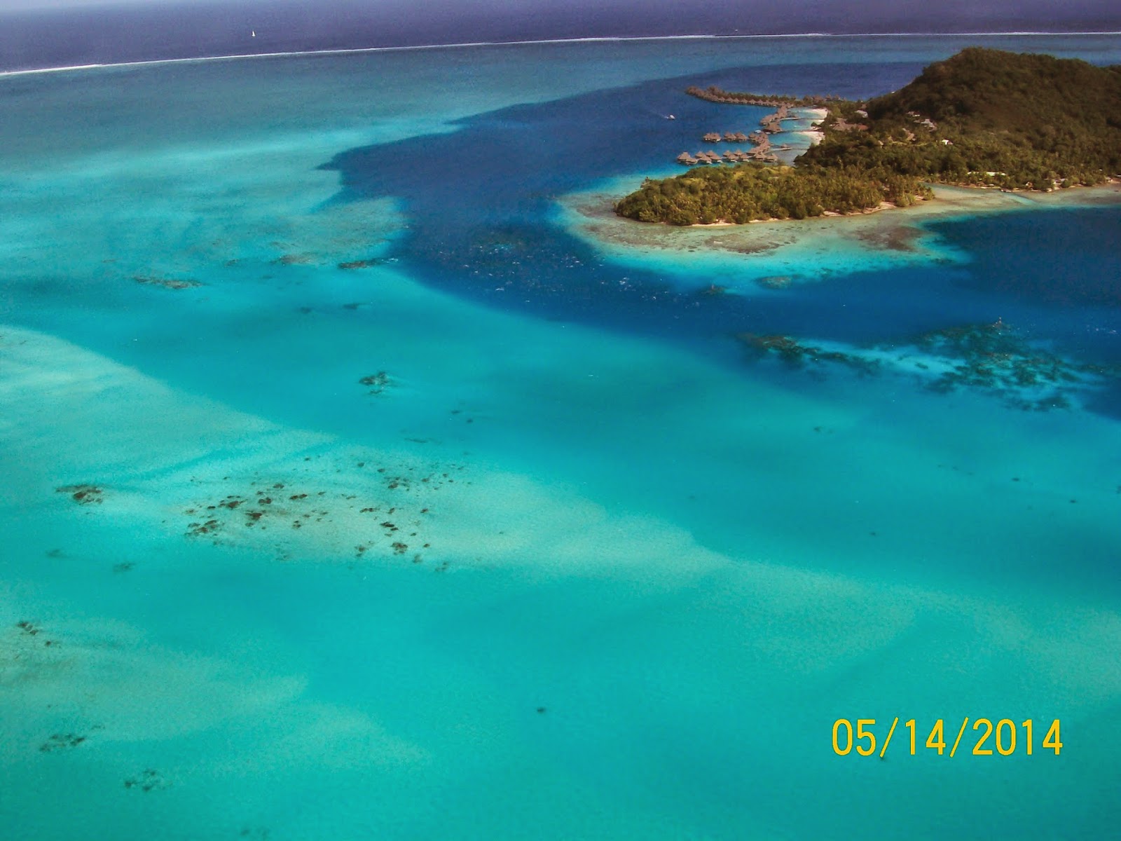
This is a good view of Teavanui Pass. That is the main channel that the boats can navigate into the lagoon area.
 |
| The lagoon around Bora Bora. |
I thought it was pretty seeing this sail boat moving in the lagoon.
Just look at the colors of the see. The light color is shallow water and the darker blue is deeper.
We flew toward an islet called Toopuaiti.
 |
| Toopuaiti an islet. near Bora Bora |
It was fascinating to see this barrier reef and the waves breaking on it with just a little bit of land being exposed.
Another view of the coral reef that surrounds Bora Bora.
From best I can tell this is Motu Tofari and those U shaped things are huts that are part of a hotel.
Then she turned the chopper and I could see more of the main island. As you can see from the number of white roofs there are not a lot of people who live on the island. I've seen different figures and am not sure what the correct number but I feel its safe to say less than 10,000 live on 15.6 sq miles.
I was getting to see Mount Rufau (139 ft) at the tip and Mata Pupu (236ft).
Looking to the other side where they had a better view of the highest peak Otemanu (727 ft)
I was pleased when she turned the helicopter again and I got a better view of Otemanu.
Yes this was definitely a volcano (
http://en.wikipedia.org/wiki/Volcano ).
 |
| Otemanu (727 ft) on Bora Bora |
I got excited to see this feature on the volcano - it was a dike
http://en.wikipedia.org/wiki/Dike_%28geology%29 .
I enjoyed looking at the volcanic rock and just wished I could be up closer to observe it better.
This is looking back on the dike. I knew I wouldn't have seen this if I wasn't in the helicopter since it was on the other side of the island where the main pass was.
Having the airport there helped orient me and figure out what I was see. The islet in the center is Motu Toopaeraro and to its right is Motu Ome. The Airstrip in on Motu Mute and I've heard it called different name and am not sure of its exact name.
I thought since we were going to be flying in a helicopter we'd be taking off from this air strip since its made Bora Bora so famous during World War II. i was wrong we took off from a soccer field gathering area.
 |
| The air strip on Motu Mute, Bora Bora |
It was so different seeing all these motu's . Each one of them has a separate name. I think the big one in the center is Motu Moute. The one thing that struck me was how difficult it would have been to get to them if you were approaching them from the ocean.
I just thought these were so pretty and different to see. I just had to include a couple of shots of them from different angles.
The sail boat couldn't get any closer and i wondered if they had to wade into the shore line or if there was a raft or something that they could use as a tender to get to the shore.
Just look at how remote this location is for a hotel. I could understand why it has a reputation for being popular with the celebrities.
Motu Ahuha and the Teavanui Pass.
 |
| Motu Ahuha and the Teavanui Pass, Bora Bora. |
And before we could help it we were back to where we started. We were suppose to have a longer trip but the weather was bad that was coming and it was cut short.
Even though we were on the same helicopter ride what I was seeing and taking pictures of was totally different from what my spouses was. Normally he doesn't take a lot of pictures - he leaves that up to me. I was surprised he took as many as he did and they were just as good so I'm going to do another post of his images.


No comments:
Post a Comment