Blogging helps me share things with people. My goal is for you to see something that brings a smile to you.

Sunday, October 28, 2012

Rib Mountain, Wasau Wisconsin

My niece got married in Wisconsin.  The wedding reception was at Rib Mountain / Granite Peak Ski resort in Wausau Wisconsin  http://en.wikipedia.org/wiki/Rib_Mountain_%28town%29,_Wisconsin .   Here's some more on Rib Mountain http://en.wikipedia.org/wiki/Rib_Mountain
 and Granite Peak Ski area http://en.wikipedia.org/wiki/Granite_Peak_Ski_Area
    What really got to me was the reception place was called Granite Peak but when I looked at the rocks expecting to see granite all I saw was quartzite. I did not get a sample because I was dressed up and didn't have a purse with me and no place to store it.  I closeup of the one rock I tried to take was too blurry to post.  Oh well - at least I got some wonder other photos.
     It was a fun reception and different.  We were allowed to ride the ski lift.  Even though there was no snow on the ground it was and incredibly beautiful ride and one you won't forget doing.

Look and see for yourself.
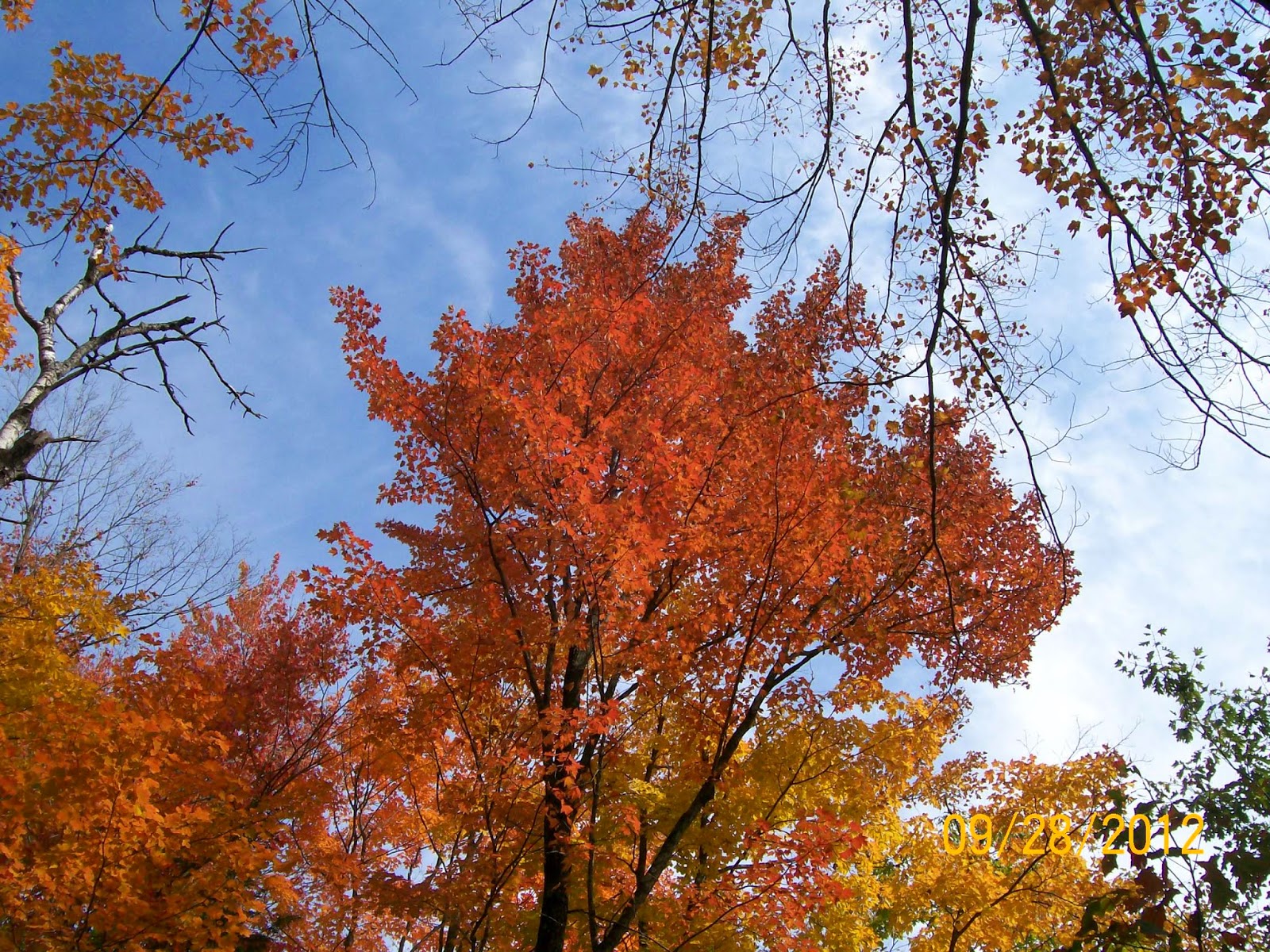
Rib Mountain ski lifts during the fall


fall foliage on Rib Mountain


View of Wausau Wisconsin from Rib Mountain
  The ride was so pretty we just had to do it again.
 This time I tried to get some images of the rocks.


 I did catch the bride and groom alone for a moment together.  I just wished when we passed the setting would have been a little prettier.
 This is were they took the wedding pictures. What a lovely setting for them
 Coming down again we kept on hearing a gobbling sound and couldn't figure out where it was coming from. 
 I was so startled when all of a sudden a pheasant flew up and by us.  I was amazed I got this picture when I did.
 Here's were the reception dinner was being held.

 We had such a good time and I was so happy that my niece has found someone to be with.

As to the geology of the area from what I can tell - because there was so much quartzite - It probably was a beach area with a lot of sandstone.  The sandstone was pretty pure with not a lot of other stuff in it - it may have been aeolian dunes?  that then later got metamorphized.  I could tell it was a quartzite because of the way it would fracture through the quartz and not around the grains like a well cemented sandstone would normally be.  Here's what Wikipedia has to say about quartzite  http://en.wikipedia.org/wiki/Quartzite  .

 
PS I've finally been able to come back to this post and give a little insight into the rocks. 
 I have the" Roadside Geology of Wisconsin" book by Roberty H Dott and John W. Attig (2004)  pgs 59-68.
These rocks should be PreCambrian in age.  The best I can tell they are part of the Wolf River Igneous Complex.
     As it says in its name its complex.  Here's quoting from Dott & Attig pg 61- 63.
'Approximately 12 miles north of Stevens Point at the Portage-Marathon County boarder (mile 171.5 -Interstate hwy 39/US51)  the highway crosses a major boundary between the Marshfield continent and the Peokean belt.  It is concealed along the highway, but in scattered exposures to the west along the Big Eau Pleine River a zone of intense shearing marks the fault zone suture between these provinces.  The faulted boundary is traceable from a little east of I-39 for 100 miles Northwest, where it disappears beneath flat-lying Cambrian Strata.  North of the boundary, Archean rocks are absent and Peolean volcanic and granitic rocks predominate.  Regardless of where the Marshfield Archean rocks originated, they must have been close to their present position during the Peokean episode for them to have been intruded by various Penokean-age igneous rocks around 1,850 to 1830 million years ago. At Mosinee, Peokean  granitic and other igneous rocks are exposed. "
  On page 6-9 this is what they have to say about Precambrian WI at about this time.  "Beginning about 1,900 million years ago, everything changed when a volcanic island chain loomed out of the sea across central Wisconsin  and erupted volcanic rocks.  the surrounding sea was deeper than earlier seas- the remaining sediments are characteristic of deep water.  The seafloor south of the early continent deepened as it was subducted and the island chain moved northward, finally colliding with the margin of the old Superior continent to form the Penokean Mountains, Wisconsin's "Rocky Mountains" Granites that were intruded widely during this collision yield dated from  1890 to 1815 million years.  Geologist have traced the roots of those old mountain from Michigan across Wisconsin at least as far west as Minnesota, and they represent a major addition to the Superior continent.
   Nature was not though mangling Wisconsin.  for less than 100 million years later, a new heating event produced more granite and the eruption of much rhyolitic volcanic material across the southern half of the state.  When calm returned, a thick succession of red sandstones, black shale's and another banded iron formation were deposited across Wisconsin and Minnesota. There in turn were crumpled and metamorphosed around 1650 million years ago.  And 200 million years later a large granitic complex called the Wold River Batholith was intruded in east-centeral Wisconsin.
   The final Precambrian episode involved a very different behavior of the earth's crust across northwestern Wisconsin and adjacent Minnesota.  Continental rifting there, called Lake Superior rift, threaten to tear North America in half, causing the two halves to drift apart.  This crisis began with the eruption of enormous volumes of basaltic lavas along a great depression in norther Wisconsin and adjacent Minnesota around 1100 million year ago.  after the eruption ceased, subsidence of the ruptured crust continued for at least 200 to 300 million years, and thick red conglomerates, sandstones, and shales were deposited within the rift.  Hot solutions percolating through the basaltic lava rocks and overlying conglomerate deposited much pure copper, which was the basis for an important copper mining industry, especially in northern Michigan, for more than a century.  This was the source for pieces of copper that Quaternary glaciers carried into Wisconsin hundreds of million of years later."

From what I observed these rocks should be the ones where there was rifting occurring and the granitic material intruded into the basaltic rocks.  As you can tell its very complex and I didn't have enough time to really look at and figure this out all on my own.

***
Geologic maps of Wisconsin and some information on the Wolf River Igneous Complex.
http://wisconsingeologicalsurvey.org/pdfs/pgszpdf/bedrock_geology.pdf


http://tin.er.usgs.gov/geology/state/sgmc-unit.php?unit=WIYhp%3B0
Wisconsin's rocks


Saturday, October 20, 2012

Eau Claire Dells, Marathon Co Wisconsin


Eau Claire Dells, Marathon Co Wisconsin park entrance

 My niece got married in Wisconsin in the fall of  2012.  She picked a time when the fall colors were going to be at their peak.  Because one of my nieces was going to be in the wedding we all got there a day early so we could visit and have a good time.
     On Friday, we all decided to go to Eau Claire Dells and spend the morning there.( there's not much about the place but here's what Wikipedia has to say about the Eau Claire River http://en.wikipedia.org/wiki/Eau_Claire_River_%28Chippewa_River%29
     You couldn't have picked a prettier day if you tried.  The temperature was perfect - low 70's.  The sky was bright blue and the trees were in full fall colors.    I felt like I was in heaven, surrounded by my family and seeing unbelievable beautiful things. The rock outcrops made me drool they were so great.  The fall colors where incredible too.  Since it was a school day for most of the area we basically had the place to ourselves which was so different from when we had been there before.  Also the water was at a low stage and so we could actually get on the rocks and look at them.

Some of the photo's I took are here.  There were a lot more but I had to force myself to narrow them down to these- Be prepared to look at a lot of them.
 I liked this one because it showed a lot of glacial erratics/ boulders and also the fall colors.

Here's a close up of one of the boulders.  From what I could tell it looked like granite. 
 I did get a piece and here it is.There's lots of feldspar in it.  I was glad I was able to get a few pieces home.  I tried to get small pieces.  Since we were only there for the weekend we flew there and I just had the one carry on piece of luggage.  I put the specimens in it not thinking about it being a potential weapon.  When I was going through the system I got caught with it.  Luckily the inspector looked at it and asked why I would have it.  I explained I was a geologist and these were really old pieces of rock unique to this area.  I had gotten them from Eau Claire Dells.  He was really familiar with the Dells since his family had a place next to it and was curious as to what the rocks were.  I told him that one was granite, the other a gneiss and the other piece (which I can't find now) basalt? or banded iron - needed to look at it with better equipment.
 here's a fresh surface of the gneiss looking piece.

  Now more on the park itself.
 This is the covered picnic area where we ate our lunch.

 One of the things I hadn't seen in a long time was a pump like this to get water.  Also the restrooms were nothing but an outhouse and my nieces were so funny about it - they had never seen one before.  When I went to use it - they ran up to me and tried to keep me from going in saying its so nasty.  I assured them I knew what I was going into and thanked them for the warning.
 The ground cover really surprised me.  It was so course I expected to see more clays and sands. 
 Going for a walk we could help but admire the colors of the trees.  So vivid and bright.

 As we were walking to the Dell area (a dell is from the French word  dalles, or narrows - or gorge), I noticed these rocks outcropping.  they were well weather but looked like they were part of the pink granite. 
  Then we got to the stairs to go down and this is what it looked like.  Yes it definitely was a gorge.

The Eau Claire Dells, Marathon Co WI

Another view 
 We came to this sign about the Ice age and it was pleased to see that they had something like that here.

 When I had studied geology at Cleveland State University we did have a field trip to Kelly's Island and I'll never forget seeing the glacial grooves in the rock http://en.wikipedia.org/wiki/Glacial_grooves.  This place looked like that too only not on the same scale.
Glacial striations or grooves at Eau Claire Dells, WI


Here's yours truly trying to gracefully climb down the rocks to look at them.  

 There were three different rock types here.  The pink granitic one, a gneiss and then a basalt maybe iron?? rock.  From what I could tell.  Granite looked liked it intruded into the other rock and the gneiss was the zone where it altered the existing rock and then the other rock the oldest.  It all looked like it was part of the PreCambrian system.  Now I have to do research to find out if I'm the right track about my observations. 
 I liked this natural grotto that was here.  Notice the vertical fractures
 The water was very pretty seeing it going through the gorge.
  The gneiss pieces were gotten low and if you look closely you can see a lighter color band that is lower near the water.
Notice the rocks on the left don't have the vertical fractures like there are in some of the other rocks.
When you look at these rocks you can tell that they are two different types on either side of the river.  the left has some vertical fracturing and is darker in color while the outcrop on the right is pinker in color and has more of a layered fracturing.
 Scour marks. 

This area had more of a layering fracturing.
 Closer view of the grotto. With vertical fracturing
A contact area between the two.  Notice the pink on top and the grey below. 
 I liked this one of the bridge.
Eau Clair River, Marathon WI


 My nephews & nieces ran ahead and I thought this was cute to find.  I wonder which one did it.


 Some of the vegetation was just breathtaking beautiful.
 We saw this tree and thought it was interesting because of the fungi that was growing on it.
 A closer look at the fungi.


 I just thought that this was a very scenic bridge and photo oportunity.

 the view from the bride.  Looking downriver.
 The other side looking up river.
 Another view down river.
  Looking back at it.


 There was this shelter where the locals like to hang out. 
 I liked seeing this rock outcrop.  It looked like it was an Indian head.  Makes me wonder if it was natural or if someone had help shape it.
 Another view of it.

 the leaves were so vividly color that these images just do not do them justice.  Just look at this red oak and how vibrantly red it is.
 One last view of the river before we went up to the park area.
 After the walk it was fun to watch the kids play in the park.
.  

PS I've finally been able to come back to this post and give a little insight into the rocks. 
 I have the" Roadside Geology of Wisconsin" book by Roberty H Dott and John W. Attig (2004)  pgs 59-68.
These rocks should be PreCambrian in age.  The best I can tell they are part of the Wolf River Igneous Complex.
     As it says in its name its complex.  Here's quoting from Dott & Attig pg 61- 63.
'Approximately 12 miles north of Stevens Point at the Portage-Marathon County boarder (mile 171.5 -Interstate hwy 39/US51)  the highway crosses a major boundary between the Marshfield continent and the Peokean belt.  It is concealed along the highway, but in scattered exposures to the west along the Big Eau Pleine River a zone of intense shearing marks the fault zone suture between these provinces.  The faulted boundary is traceable from a little east of I-39 for 100 miles Northwest, where it disappears beneath flat-lying Cambrian Strata.  North of the boundary, Archean rocks are absent and Peolean volcanic and granitic rocks predominate.  Regardless of where the Marshfield Archean rocks originated, they must have been close to their present position during the Peokean episode for them to have been intruded by various Penokean-age igneous rocks around 1,850 to 1830 million years ago. At Mosinee, Peokean  granitic and other igneous rocks are exposed. "
  On page 6-9 this is what they have to say about Precambrian WI at about this time.  "Beginning about 1,900 million years ago, everything changed when a volcanic island chain loomed out of the sea across central Wisconsin  and erupted volcanic rocks.  the surrounding sea was deeper than earlier seas- the remaining sediments are characteristic of deep water.  The seafloor south of the early continent deepened as it was subducted and the island chain moved northward, finally colliding with the margin of the old Superior continent to form the Penokean Mountains, Wisconsin's "Rocky Mountains" Granites that were intruded widely during this collision yield dated from  1890 to 1815 million years.  Geologist have traced the roots of those old mountain from Michigan across Wisconsin at least as far west as Minnesota, and they represent a major addition to the Superior continent.
   Nature was not though mangling Wisconsin.  for less than 100 million years later, a new heating event produced more granite and the eruption of much rhyolitic volcanic material across the southern half of the state.  When calm returned, a thick succession of red sandstones, black shale's and another banded iron formation were deposited across Wisconsin and Minnesota. There in turn were crumpled and metamorphosed around 1650 million years ago.  And 200 million years later a large granitic complex called the Wold River Batholith was intruded in east-centeral Wisconsin.
   The final Precambrian episode involved a very different behavior of the earth's crust across northwestern Wisconsin and adjacent Minnesota.  Continental rifting there, called Lake Superior rift, threaten to tear North America in half, causing the two halves to drift apart.  This crisis began with the eruption of enormous volumes of basaltic lavas along a great depression in norther Wisconsin and adjacent Minnesota around 1100 million year ago.  after the eruption ceased, subsidence of the ruptured crust continued for at least 200 to 300 million years, and thick red conglomerates, sandstones, and shales were deposited within the rift.  Hot solutions percolating through the basaltic lava rocks and overlying conglomerate deposited much pure copper, which was the basis for an important copper mining industry, especially in northern Michigan, for more than a century.  This was the source for pieces of copper that Quaternary glaciers carried into Wisconsin hundreds of million of years later."

From what I observed these rocks should be the ones where there was rifting occurring and the granitic material intruded into the basaltic rocks.  As you can tell its very complex and I didn't have enough time to really look at and figure this out all on my own.

***
Geologic maps of Wisconsin and some information on the Wolf River Igneous Complex.
http://wisconsingeologicalsurvey.org/pdfs/pgszpdf/bedrock_geology.pdf


http://tin.er.usgs.gov/geology/state/sgmc-unit.php?unit=WIYhp%3B0
Wisconsin's rocks