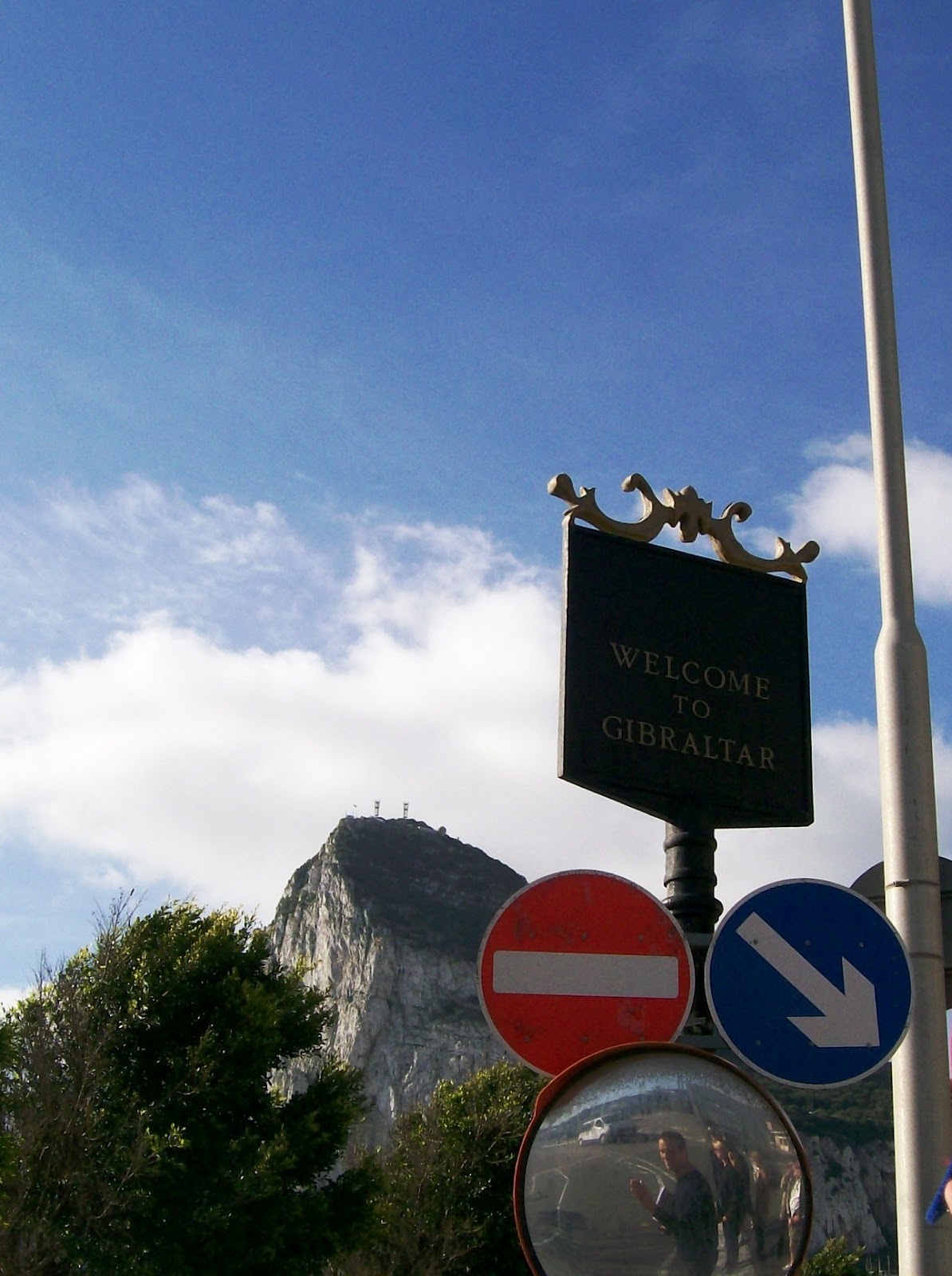
'The Rock Of ...' What Geologic Formation do you think of? Is it Gibraltar?
I don't know about you but it is me when I hear The Rock of ... Gibraltar. It just goes together without thinking. Because of its name it has always intrigued me. One of the things I've always wanted to see ever since I started to study geology was the Rock of Gibraltar. And this trip I finally had that goal achieved thanks to a company that doesn't want to be named.
Here's what Wikipedia has to say about
The Rock_of_Gibraltar .
So to get the geology right I'm going to just copy from Wikipedia the information that is in The Rock of Gibraltar.
'Geology
The Rock of Gibraltar is a monolithic promontory. It is a deeply eroded and highly faulted limb of an overturned fold. The sedimentary strata comprising the Rock of Gibraltar are overturned (upside down) with the oldest strata overlying the youngest strata. These strata are the Catalan Bay Shale Formation (youngest), Gibraltar Limestone, Little Bay Shale Formation (oldest), and Dockyard Shale Formation (age unknown). These strata are noticeably faulted and deformed.[6]
The Catalan Bay Shale Formation consists predominately of shale. It also contains thick units composed of either brown calcareous sandstone; soft shaly sandstone interbedded with bluish-black limestone; and interlayered greenish-gray marls and dark gray cherts. The Catalan Bay Shale Formation contains unidentifiable echinoid spines and belemnite fragments and infrequent Early Jurassic (Middle Lias) ammonites.[6]
The Gibraltar Limestone consists of greyish-white or pale-gray compact, and sometime finely crystalline, medium to thick bedded limestones and dolomites that locally contain chert seams. This formation comprises about three quarters of the Rock of Gibraltar. Geologists have found various poorly preserved and badly eroded and rolled marine fossils within it. The fossils found in the Gibraltar Limestone include various brachiopods; corals; echinoid fragments; gastropods (including ammonites); pelecypods; and stromatolites. These fossils indicate an Early Jurassic age (Lower Lias) for the deposition of the Gibraltar Limestone.[6]
The Little Bay and Dockyard shale formations form a very minor part of the Rock of Gibraltar. The Little Bay Shale Formation consists of dark bluish-gray, unfossiliferous shale, which is interbedded with thin layers of grit, mudstone, and limestone. It predates the Gibraltar Limestone. The Dockyard Shale Formation is an undescribed varigated shale of unknown age that lies buried beneath the Gibraltar's dockyard and coastal protection structures.[6]
These geological formations were deposited during the early part of the Jurassic Period some 175-200 million years ago, when the African tectonic plate collided tightly with the Eurasian plate. The Mediterranean became a lake that, over the course of time, dried up during the Messinian salinity crisis. The Atlantic Ocean then broke through the Strait of Gibraltar, and the resultant flooding created the Mediterranean Sea. The Rock forms part of the Betic Cordillera, a mountain range that dominates south-eastern Iberia.[6]
Today, the Rock of Gibraltar forms a peninsula jutting out into the Strait of Gibraltar from the southern coast of Spain. The promontory is linked to the continent by means of a sandy tombolo with a maximum elevation of 3 m (9.8 ft).[7] To the north, the Rock rises vertically from sea level up to 411.5 m (1,350 ft) at Rock Gun Battery. The Rock's highest point stands 426 m (1,398 ft) above the strait at O'Hara's Battery. The Rock's central peak, Signal Hill, stands at an elevation of 387 m (1,270 ft). The near-cliffs along the eastern side of the Rock drop down to a series of wind-blown sand slopes that date to the glaciations when sea levels were lower than today, and a sandy plain extended east from the base of the Rock. The western face, where the City of Gibraltar is located, is comparatively less steep.

A panoramic view from the top of the Rock of Gibraltar looking north.
Calcite, the mineral that makes up limestone, dissolves slowly in rainwater. Over time, this process can form caves. For this reason the Rock of Gibraltar contains over 100 caves. St. Michael's Cave, located halfway up the western slope of the Rock, is the most prominent and is a popular tourist attraction.
Gorham's Cave is located near sea level on the steep eastern face of the Rock. It is noteworthy because archaeological excavations in the cave have found evidence that Neanderthals used it as far back as 30,000 years ago. It is especially significant because plant and animal remains found in the cave (and others nearby) indicate that the Neanderthals had a highly varied diet.[8]'
----------------------------
As I was looking at it I also came upon these articles on the region that discussed some of the geology in the area:
Iberian_Peninsula,
Gibraltar_Arc,
Strait_of_Gibraltar,
Alboran_Sea and finally this on
the Beatic System. I'm still looking. I just wish I knew how to read Spanish fluently so that I could gather more information about the geology. Its so complex. I do know one thing - one of my guides was complaining about how they do not have a lot of geologic mapping like they do in the United States of the area and really felt it would help. He did say they sure could use an USGS in this region.After seeing what I did I totally agreed with him.
I did pick up a book 'A Guided Tour of Gibraltar' by T. J. Finlayson (couldn't find copy right date but I think its 2011) which has helped me a lot in writing this post. So often as we were driving by the guide was telling us about multiple things and I wasn't always sure what was what. It was nice to refer to this guide and figure things out.
My Impressions of Gibraltar
Now it's on to what I got to see while I was there. We drove down The Costa Del Sol region using A-7 and started from Marbella. It was not a bad trip and took over an hour to get there.
This was my first image of it when we drove to it. It's not the best because it was taken from the bus and we were traveling pretty fast. I had to take this during a rare time when something else wasn't blocking it. Also most of my pictures taken from the bus are not the best since there was glare from the windows and the windows were tinted thus leading to some strange color of things.
 |
| Northern side of the Rock of Gibraltar seen from Spain |
I had forgotten Gibraltar was a peninsula and was surprised at one point of being able to see water on both sides. I did get this image of it so you get an idea of what it looks like to the Spaniards This looking at its north eastern side.
 |
| Gibraltar bay and the Rock of Gibraltar |
I also forgot that Gibraltar is part of Great Britain and not Spain and that we would have to go through customs to get in.
 |
| The Boarder between Spain and Gibraltar |
On of the first things you see is the Gibraltar airport. It is one of the most unusual airports I have ever seen. The main road goes right across the runway. And the runway was built out into the bay, so on either end of the run way you are dealing with water.
 |
| Gibraltar Airport |
(I must apologize now because a lot of these photos are taken from the bus and there is some reflections in them and also the windows where tinted thus affecting the colors somewhat. Yet the pictures are so typical of what we were seeing I've gone ahead and used them so you can get an idea of what this place is like.)
One of the first things to catch my attention was this castle looking thing. I came to find out later it was indeed a castle built by the Moors. Now that is something I don't get to see very often - A castle. The way it commands a view I could understand why it was built where it was. You would definitely see any movement in the bay.
 |
| Morish Castle |
Here's another military looking building used to control the bay
And here's the bay its watching. Look at all those ships coming and going.
We drove to the southern tip of Gibraltar which is called Europa Point. It is a park area and here you can see a Mosque in the background along with the rock outcrop..
 |
| The Mosque at Europa Point Gibraltar |
One of the prominent features is its lighthouse. I've always liked lighthouses and had to get this picture.
This is looking back to the top of Gibraltar from Europa point.
 |
| The Rock of Gibraltar from Europa Point. |
My husband was fascinated by seeing all the ships going into the Mediterranean Sea. He started to count them and I forgot how many he saw but it was over 30 of them.
 |
| Ships in the Strait of Gibraltar |
I found it just fascinating to be able to see Africa. At its narrowest point there is about 9 miles of sea separating Europe and Africa.
 |
| Viewing Africa from Europa Point, Gibraltar |
And here's a better picture of Africa and the ships going through the strait.
 |
| Cargo ship sailing on the Strait of Gibraltar with Africa in the background. |
The reason Gibraltar is part of Great Britain and not Spain is because the British realized back in the 1700's that who ever controlled Gibraltar would control the Mediterranean Sea. This was a choke point for ships. IE if you wanted to move cargo by ship anywhere in the Mediterranean it will probably go by this point at one time or another if its to have any other dealings with the rest of the world.Its not surprising there have been battles with Spain who was trying to regain control of this region. This whole community exists where it does so that it can control the sea. The inside of the Rock has been made into a fortress and is totally self contained with its own water purification facilities, and power plant. They say there is enough food stored there to last sieges for years- and there is some fishing that can be done there too. It did not surprise me at all to see this huge cannon on top of the Rock at this point.

And here's a crop view of that cannon. That cannon can shoot all the way into Africa for a distance of about 22 miles.
 |
| Cannon on top of Gibraltar |
Because the Rock of Gibraltar has been so safe and secure for so long - now a days its used as a symbol of security.
As we drove along I was surprised to see there was so much vegetation there. I always pictured it as a rock outcrop. I wasn't expecting so much of it to be covered on the western side. Here's two pictures I took from the Bay of Gibraltar looking at the western side.
 |
| Western side of Gibraltar looking south |
This one is looking back to where the main living and activities are.
 |
| Viewing Gibraltar ports from the Bay of Gibraltar looking north |
Continuing with our tour we went up the Europa road to St Michael's Cave. (The Cave is so magnificent it called for its own post just on
St Michael's Cave and there is another one upon the
Barbary Macaque (monkeys) that live near the cave.) The drive was spectacular too. I just wished we had more time and space so we could stop more, unfortunately our tour bus was too big to just pull to the side and we had to keep on going.
 |
| Pillars of Hercules monument, Gibraltar |
 |
| View along Europa Road, Gibraltar |
 |
| This is the point were Queen Elizabeth visited overlooking the bay of Gibraltar. |
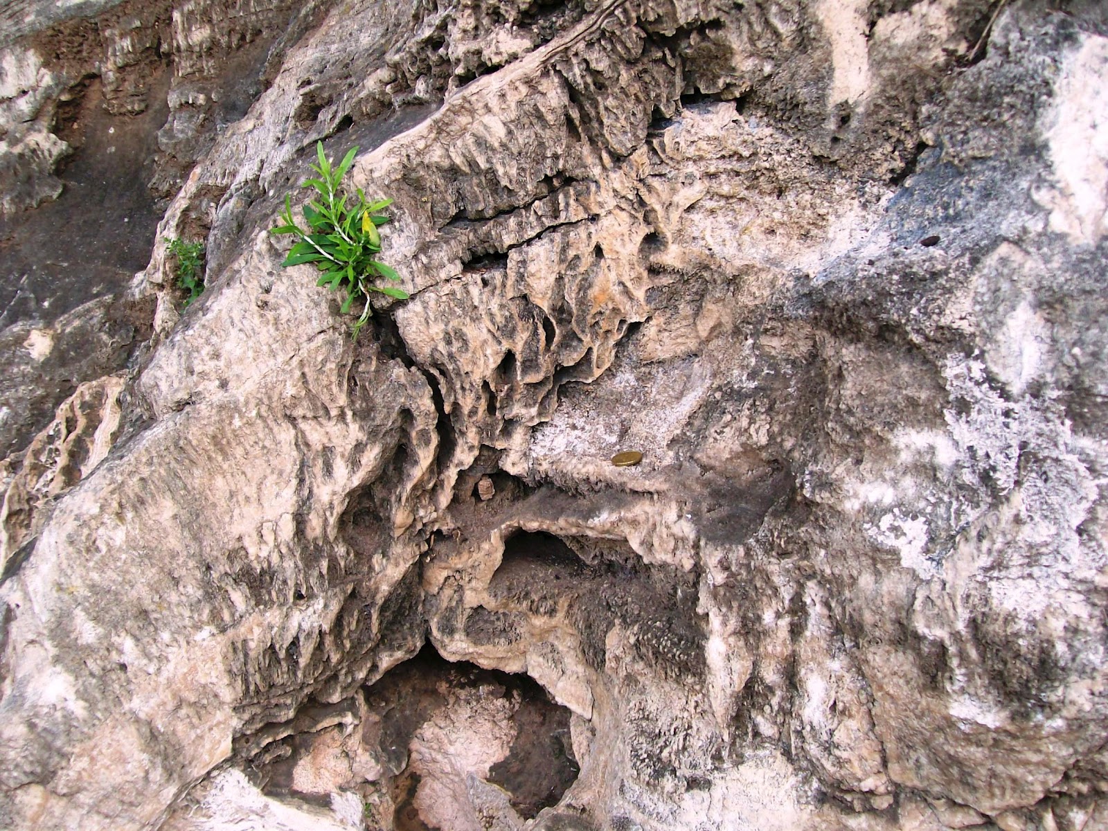
When we stopped at St Michaels Cave I finally got the chance to get out and to actually look at some of the outcrops in the area. Since I knew the cave was made of limestone it did not surprise me at all to see that the outcrop was a limestone too. One of the things that was interesting to my husband was seeing these iron rings along the road. We found out later that these rings were place there to help pull cannons around the island.
 |
| Iron ring cemented in the Gibraltar limestone outcrop. Used for pulling up guns |
A different ring cemented into the limestone outcrop.
 |
| Gibraltar Limestone |
I thought this was interesting because it looked like the limestone had been dissolved and recrystallized into the vugs in the area.
 |
| Gibraltar Limestone Outcrop |
And another ring.
 |
| Gibraltar Limestone |
As I was trying to get this picture I went to put a coin on it for scale and saw this little guy and fell in love with it....
 |
| snail on the Gibraltar limestone outcrop, Gibraltar |
A closer view. Isn't it cute!!. Escargot anyone? But in reality I didn't want to eat it but just take it home with me. This was one time I wished it was a fossil but it was moving so I knew it wasn't. As it was the guard was watching everything I did and I was afraid to even try to get a rock sample, let alone this critter.
No wonder their ceramics are decorated like they are - when you have thing from mother nature to inspire you like this.
 |
| A live snail on the Gibraltar limestone |
Sadly our time ran out and we had to get going again.
 |
| Bay of Gibraltar |
If you look just above the cannon and car you can see that runway I was talking about jetting out into the bay.
 |
| Bay of GibraltarThis road got our attention because of its name. |
You can see the name in the lower left hand corner.
 |
| Bay of Gibraltar |
 |
| Morish Castle and the city below. |
Not the best picture but it gives you an idea of how the Moorish castle is situated and the view of the bay it has.
 |
| The Tower of Homage, Moorish castle at street level. |
The guide pointed out that the curved windows in this building is very typical of the Moorish style of architect, and that this building was very old yet very typical of the building that were built by the Moores when they occupied the area in the 1400's.
 |
| Typical Moorish curved windows. |
This is a point of interest but forgot what was said about it. I think it is attached to the hospital. And I think this is the hospital that they take the monkeys to if they get sick. In Gibraltar there is a legend that the British will leave the rock when the last monkey dies. The British take very good care of the monkeys even though they are wild. I guess it means they want to stay there. They have their own vet that all he does is study them. From time to time they will bring in some new blood to maintain the monkey population and to bring diversity to the genetic pool.
 |
| Kings chapel built in 1540, Gibraltar |
 |
| The Convent, Gibraltar |
I just liked the building above. Its the official residence of the Governor. Below was the military barracks.
 |
| The Line Wall Promenade |
This wasn't the best shot but I had to include it because it was the American War memorial.
 |
| The backside of the American War Memorial |
I don't see phone booths very often, so I just had to get a photo of it. The guide joked about it not being Blue but maybe we should look for Dr Who anyway since that's the only reason he could think of there being a phone booth here at this location.
 |
| Phone booth at Casemates Square, Gibraltar |
My husband thought this gun was so fascinating. Because of the heights on the rock the guns had to point down to shot their targets. These guns had to be modified so they could achieve this goal.
 |
| Koehler depression gun carriage. |
I muse: I wonder how long it took for it to be figured out that the Rock of Gibraltar was an overturned anticline?


No comments:
Post a Comment