
My son is away at camp and traditionally while my children are away at camp my husband and I like to take a vacation too. This year we wanted to do the same however since we just had had a major trip to the Alps we were limited with our time and resources so we decided we would just have to keep it to a weekend retreat somewhere. It had to be some place we could drive to. We got out the maps and started to talk to people. One place that came up more than once was the Hill Country and vineyards west of Austin. We have been to Austin but not really the Hill Country of Texas. Or I should say I never really had been in the area, my husband has when he went to college in San Antonio but that was many a year ago and things have changed since then. For one thing there are vineyards - something that has come about over the last 20-30 years. In fact its now the 2nd largest wine producing region in country with over 36 vineyards listed in their wine country brochure.
My husband was talking to some co-workers of his about our planned trip and one of them told him about this 'Enchanted Rock' near Fredericksburg and said he really had to take me there since they knew I loved seeing unique geological features. So we planned the trip so that we could see it Saturday morning and then move on to Fredericksburg since it really wasn't much out of our way. I'm so grateful to that friend for convincing my husband to do this. It was well worth the detour.
Enchanted Rock is a state park ( http://en.wikipedia.org/wiki/Enchanted_Rock ) that is located north of Fredericksburg on Highway 965.
When I go to an area I'll read up about the general things but I like to keep away from the geological material so that I can see it without any preconceived ideas. Enchanted rock was no exception and all I knew was its name 'ENCHANTED ROCK'. With a name like that I figured it must be one very special rock and was curious as to why would it be called that. I could hardly wait to find out.
So as we were driving towards it - it didn't take long to figure out where we were going. Once I saw it I knew it had to be the special rock to be called enchanted.

For one thing it was pink and the other thing was there was very little vegetation on it. As soon as I saw it - it reminded me of Stone Mountain near Atlanta Georgia (Stone_Mountain). While I never did get to go up onto the mountain - it was closed when I was there due to road work I did get to drive around it and could tell it was a granite type (ie light colored silicias continental vs dark mafic oceanic) batholith/ monadnock. This was just like that so I expected it to be granitic too.
While we were driving there I did see this distant feature:

 | |||||||||||||||
| Hwy 965 and a distant view of the Enchanted rock. |
The first rock I saw I just had to get a picture of it. It definitely looked like a granite or something in the granite family to me. My expectation was met.

We had to decide whether to walk the perimeter or to hike up to the summit. We chose to hike up after we saw someone and asked how long it would take. They said about an hour and since we were under some time constraints for the place we were staying we decided that was the more doable option.


It wasn't long before I noticed we were on granite. I also noticed how rough & large the grains that were weathering off of it.


 |
| Exfoliation on Enchanted Rock |

I loved looking at all the different weathering features I was seeing. In the photo above just look at the way the rock was peeling off in layers. To me it was textbook classic exfoliation. Also you could see where water had gotten in between joints and worked away with acidic waters with it too.


More exfoliation features.


 |
| Unique weathering of granite on Enchanted Rock, Texas |
The farther up the better the view. I pooped out before getting to the top but was very happy with what I had seen and done to that point. I could have done it if I had more time but we needed to get going. Also earlier we had climbed all around Longhorn Caverns and was tired from that (but that's a different post). Here's some of the view we did get to enjoy.
To the left - north.

Looking straight out to the east. Does that look like a fault line to you? It sure does to me.

To the right- south east

To the right - south.

And of course to the west was to the summit.

When I got to the point where I had to stop and rest I stood there looking at everything and started to wonder about this rock and how it got to be here like it was. Since I saw that line that looked like a fault, and the area in between being lower I reasoned that it must be a graben. Thinking back to my field camp days of 30 years ago, I saw grabens like this in Nevada and found out it was due to normal faulting. Normal faulting occurs when the forces are pulling the bedrock apart from each other and stretches the surface. The stretching forces causes fractures occur - if the fractures get pulled apart enough then sometimes igneous material can get intruded into those zones of structural weakness and a volcano may occur if it reaches the surface. If the volcano becomes dormant for awhile then the inside material can solidify into a granitic rock. Then with time the outside material gets eroded away and the granite is left there as a batholith. As it weathers the overburden pressure is removed creating joints that are parallel to the surface and the granite weathers like an onion peeling layers off one at a time. I reasoned this was probably what had happened here. I wondered if this was a remnant from the breakup of Pangea and was an old abandoned spreading zone. At that point I really wished I had a mass spectrometer there so I could figure out the age of this rock. Knowing the age of the granite would help so much in solving the mystery of how it formed.
After I got home I did some reading up on the area, with most of my information coming from 'Roadside Geology of Texas" by Darwin Spearing (1991).
Boy was I WRONG about my reasoning. The above scenario is not what happened. If I just had gone up to the top I might have figured out where my reasoning went wrong. I would have seen that it was part of the Edwards plateau and it was not along a zone of structural weakness. Part of the problem was when I was at the Lonestar Caverns I had heard that the Llano uplift was 50 million years old. I assumed that this intrusive rock was what caused the Llano uplift and thus it was 50 million years old. The uplift only started the weathering of this rock 50 million years ago and the rock was already there. If I had gone to the top and if I noticed that the principle of superposition applied here where the younger rocks are on the top and the older ones are underneath then I might have realized that these rocks were the older deeper rocks. When I was at the Lonestar Caverns I was told there by the guide and displays that the rocks there were Ordovician in age and they were above this structure and making this older than Ordovician. To be older it would make it either Cambrian or Precambrian in age. After reading about it in 'Roadside Geology of Texas" by Darwin Spearing I found out that these rocks are indeed Precambrian in age. He had this diagram which really helped me understand what had happen for the rocks in the area to be the way that they are. This was so much better than the other stuff that was at the park as you will see later.
 |
| taken from 'Roadside Geology of Texas' by Darwin Spearing (1991) pg 123 |
We had to get to the hotel and so I turned back before reaching the summit.
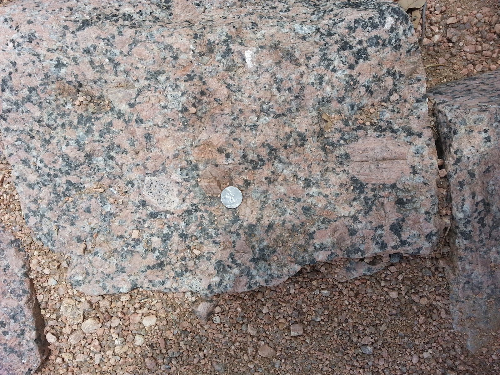
I had to stop and take this picture of the feldspar vein in this rock. Even though it was all granite material the things I was seeing in it was so fantastic and you just couldn't just walk by and not admire it. There is a penny in it for scale.


As I was descending I also saw this rock and coveted it. I wish I could have taken it home but I left it where it was and settled for some pictures of it instead.


And this is the other reason I liked it so much. Notice the big pink phenocryst feldspar crystal and how it is twinned. To have both in one spot - I just wished the rock wasn't so big and we could take samples with us.

I noticed these pools of water and remember the sign talking about them and wondered if there was any fairy shrimp in this.


This is what Wikipedia says about it:
Enchanted Rock
From Wikipedia, the free encyclopedia
| Enchanted Rock | |
|---|---|

Enchanted Rock, as seen from the trail leading to its summit on a busy hiking day.
|
|
| Elevation | 1,825 ft (556 m)[1] |
| Location | |

Enchanted Rock
|
|
| Coordinates | 30°30′24″N 98°49′08″WCoordinates: 30°30′24″N 98°49′08″W[2] |
| Geology | |
| Type | granite dome |
| Designated: | 1971 |

The prominent granite dome is visible for many miles in the surrounding basin of the Llano Uplift. The weathered dome, standing above the surrounding plain is known to geologists as a monadnock. The rock is actually the visible above-ground part of a segmented ridge, the surface expression of a large igneous batholith, called the Town Mountain Granite[5] of middle Precambrian (1,082 ± 6 million years ago)[6] material that intruded into earlier metamorphic schist, called the Packsaddle Schist.[5] The intrusive granite of the rock mass, or pluton, was exposed by extensive erosion of the surrounding sedimentary rock, primarily the Cretaceous Edwards limestone, which is exposed a few miles to the south of Enchanted Rock.[5]
What really irked me about that sign was the fact that it lead you to believe that the granite is about 50 million years old but it was only the uplift and the erosion that is that old. I thought they could have given a little bit more geologic information on it. At the check-in place I asked if they had any information on the geology of the area and all they handed me was the state parks of Texas and the rates of the different state parks. I was so disappointed that they didn't have anything more because I know this has been studied since its so close to the University of Texas in Austin. I'm sure there is other material out there and maybe some day I can do the research on it and find out more about it.
The other thing that I loved about this trip was seeing the wild flowers that I did. So many things were in bloom and I couldn't resist taking some pictures of them. Unfortunately I don't know there names. These looked like Black-eyed Susans but I'm not sure.


Post script: I came across the state geologic map and wanted to add it:
here's the link to it. http://geology.about.com/od/maps/ig/stategeomaps/TXgeomap.htm

No comments:
Post a Comment