Blogging helps me share things with people. My goal is for you to see something that brings a smile to you.

Tuesday, April 16, 2013

Rock House - Hocking Hills State Park, Ohio

I went to a reunion in Southeast Ohio.  Then after the reunion I was going to go up north to visit my mom.  I drove home along the roads that I used to commute back and forth when I would go to school at Athens.    Frequently when I was in school my friends and I would make excursions to the Hocking Hills State Parks on our commute to and from the school.  I have some very found memories of the park, but never took any pictures since they were usually spur of the moment sideline trips and not planned out excursions.  One of the places I did enjoy visiting was the Rock House.  This time as I was traveling north I decided to make another sideline excursion to the Rock House but this time I made sure I had my camera and cell phone with me to take pictures.  The cell didn't get any reception in the area I was so I did leave that but did take my camera.

Now to let the pictures do the talking.
I knew I was at the right place when I saw this.:
I had stopped off at Old Man's Cave too on this trip and at that place I was able to pick up a Hocking State Park guide.  I was glad I had since there really wasn't much here as far as facilities went.

I followed the trail to the Rock House by going along the upper edge. As I recalled it was a loop around with the path going along the upper edge and then looping back through the caves and then ending back at the parking lot.  I knew there were hills to climb and thought it best to do it first while I was still rested from driving and not all tuckered out from hiking.

I did recall having to be very careful while walking along the edge because the drop-off is more severe than it appears at first.
Its a pretty hike and really wasn't too bad to do.
I got excited when I started to see the Blackhand Sandstone jetting out like this and forming those cliffs. The Blackhand Sandstone is a member of the Cuyahoga Formation, deposited during the Mississippian Period about 350 million years ago.


The one thing I remembered most about this area was the jointing you would see. http://en.wikipedia.org/wiki/Joint_%28geology%29
 You really couldn't call them faults because there was very little displacement along them but the formation would definitely have a crack running through it which would channel water also through it.  The water would scour the cracks widening them with time so that they could become vary visible. Like this one.
Joint in the Blackhand sandstone, Hocking Hills State park Ohio

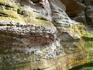
One of the things that the Hocking Hills state Park is famous for is Honeycomb weathering.
http://en.wikipedia.org/wiki/Honeycomb_weathering

Because of this weathering the assumption is that this rock formation was deposited in an intertidal area.  From other things I've observed and read the Blackhand Sandstone formation is believed to be an ancient deltaic system. 


The colors are a lot more vivid than what the camera captured.  I could auto enhance them but then it takes away from its natural beauty.  The green moss also adds a lot to the color of the rocks.
This doesn't look like much but it is one of the openings to the Rock House.

Blackhand Sandstone cliffs of Rockhouse - Hocking Hills State Park, Ohio


I just loved the way the rocks look in these pictures. 
These were the rocks that were forming the ledge and were the caprock in the area.
I was surprised to see how much of a drop-off there still was after having climbed down to the rock house area.
Just look at these red streaks and green moss on the rocks.

Joint in Rock House - Hocking Hills State Park, Ohio

Look at the way the joints go through them and have widen with time.
After oohing and googling the rocks outside I finally ventured into the actual area that is called the 'Rock House".  According to the guide - The Rock House is considered the only true cave in the area.  It is located midway up the 150 cliff of the  Blackhand Sandstone in the middle zone area.  The ceiling is 25 feet high and the corridor is 200 feet long with a width varying from 20 to 30 feet wide.
The ceiling and floor are the two more resistant zones of the Blackhand sandstone while the middle section is the less resistant zone. There is a joint going the length of the ceiling that allowed the water into this area to weather it out. There is also small joints going into the side of it that allow light in and gives it an appearance of a Medieval church.  Because of its nature the place has been used as a hide out for robbers and a settlement for Native Americans.

I could tell by looking at this that at one time there was more water running thought it and the water was at a higher level.  Most likely that occurred when the glacier were present just north of this area.  There is no evidence the glacier where in this area but the run off was.
Inside the RockHouse - Hocking Hills State Park, Ohio
There was light but not a whole lot and it made it difficult to get a good picture of it.
Inside the Rockhouse - Hocking Hills State Park, Ohio
A ledge weathered out inside the Rockhouse.  I could just imagine a Native American family living in this place.  

Here's one of the cross cutting joints that let the light into the area and giving it a reverent feeling to the place.
just walking and taking the pictures the joint area can get a totally different look to it.

Through the years you could tell a lot of graffiti had been done on the walls.  I hope people would learn not to destroy places like this.  It should be for everyone's enjoyment.

A different area that had opened up.
The rockdawg in me liked this one a lot. I thought it look like a dog.
Here's a different view and closer up.

When I came out this is what you looked down on and you had to be very careful in picking up the trail again.

I just found the cliff walls so captivating to look at.


The other entrance to the Rock House.
This is what the other side of the gorge looked like.  Very similar to the Rock House.

I got up to the parking lot and finally found the sign that was for the lower trail to the Rockhouse.

Here's some more information about the area
 http://hockinghills.com/rock_house.html

http://en.wikipedia.org/wiki/Hocking_Hills_State_Park

http://parks.ohiodnr.gov/hockinghills

http://www.hockinghillsnews.com/news.php

http://www.americanbyways.com/listing/hocking-hills/

http://www.explorehockinghills.com/
.....

Monday, April 15, 2013

Old Man's Cave, Hocking Hills State Park- Ohio

I lost some photo's recently and I don't want to loose these.  Blogging helps by keeping them where I can find them.  I also like blogging because I can write more than one line verses what you can write on it if you tag it.
    I went to a reunion and on the way to visit some other people  I stopped off in Hocking Hills State Park.  I have many found memories of this place and wanted to get some pictures since I never really took any when I went there before.  The state park has 6 separate areas over 2,000 acres. The six areas are; Old Man's Cave; Cedar Falls, Ash Cave, Conkles Hollow (state nature preserve); Rock House; and Cantwell Cliffs.
    One of my favorite places and one of its most famous is Old Man's Cave.
Now to let the images do the talking for me.


When you get there you have to walk a path that is about a mile long to see the cave where he lived.

You barely notice there is a gorge there when you first get to it. I could see why he liked living there.  It was very secluded.
Then the water drains into this area and formed the gorge in the Blackhand Sandstone of the Cuyahoga Formation. It is of the Mississippian age - 350 Million years.  The Blackhand Sandstone was deposited in a deltaic environment, with the source rock coming from the east.   In this area the Blackhand Sandstone is 150 feet thick. The creek is called Old Man's Creek.
The rock is a sandstone and you can see the cross bedding in it.
Blackhand Sandstone at Old Man's Cave, Hocking Hills State Park - Ohio
Ohio had been experiencing a drought and even though it was spring time there wasn't a lot of water flowing through it.  It seemed like when I've been here before there was always more water and it was harder to see the outcrops. 
It hits a plateau and then it continues down. Some area's have more shale than others and the shales erode easier and form those plateaus.
There is a person in this one for scale.  What I've always been impressed with this area is the joint fractures that you see.  You really can't call them faults since you really don't notice displacement along them.  But its because of the extensive fractures and joints in the area that allow paths for the water to migrate through.  The water carries sediments in it which scours away the rocks creating these beautiful falls and scenery.

Here you can see how the waters have removed away the less resistant materials.

The water must have been higher at one time - probably when the glaciers were there and it scoured out these ledges.

See this grotto that was forming at the base of the river.
The one thing I remember about the area is that there were a lot of joints.  http://en.wikipedia.org/wiki/Joint_%28geology%29
 Just look at that joint and the way the tree has started to grow in it.  I'm sure when the tree dies and rots away where the roots dug into will be easily eroded away and thus allowing another path for the water to migrate through.
Another area that had been scoured out by water. This area if known for its honeycomb weathering - small holes in a beehive. The holes are due to the differential weathering of the sandstone.
Some of them were pretty big and I could see people like a tribe of Indians living there.


The colors in the area also make it so scenic.  The green color is probably due to mosses growing on the rocks.  The reddish colors are due to the weathering or iron that was in the rocks when it was deposited.   It is because of the reddish spots and the crossbedding that it can be inferred it was at one time a deltaic deposit.

The was a place that is called the Devils bathtub and they had this sign here to warn people not to go into it.

You can just see the water going into this area and how its scouring out the rocks as it swirls its way down.
The Devil's Bathtub - Old Man's Cave Hocking Hills State Park- Ohio
The gorge to the upperfalls channeling the water form Old Man's Creek into the Devils Bathtub area.

The Devils Bathtub at Old Man's Cave, Hocking Hills State Park Ohio
Here's another view of it and you can get a feel for how the water can scour out a place in the rocks like it does.
The Devils Bathtub - Old Man's Cave Hocking Hills Ohio


Just look at the way the Blackhand sandstone has been eroded away.


When I came to this sign I was surprise to see there was a choice to be made I just remembered it as being a loop around the area.   I decided to go to the Upper Falls.


The Upper Falls at Old Man Cave, Hocking Hills state Park Ohio


After I saw the falls I decided to go up along the rim of the gorge for awhile.

This was looking down at the river.
From here you wouldn't realize it was there.


Then I got to the area that was the cave area where the man lived.  The man that gave the place its name was Richard Rowe.  He moved to the area around 1796 and spent most of life living in this area.  He is also believed to have been buried in the area too.

This gives you an idea at how much the sandstone rocks overhang the weaker shaley rock.  And even thought this is not a true cave it did give protection during inclement weather.

This is the view that the Old man would have had when he looked out of his living area.

Old Man's cave the living area, Hocking Hills State Park Ohio
Going on the otherside of the creek and looking down on it.

Old Man's Cave where Richard Rowe Lived.  Hocking Hills state Park Ohio
Looking at the lower gorge area.


The lower falls.
Lower falls at Old Man's Cave - Hocking Hills state park, Ohio

The more resistant Blackhand Sandstone overhanging the lower falls.


This isn't the best pictures but this is the area that they call the Spinx Head.
Spinx Head at Old Man's Cave - Hocking Hills State Park, Ohio


Lowerfalls at Old Man's Cave, Hocking Hills state park, Ohio

I did like the way they made the bridges and pathway to be interesting to see while you did walk along them.
I did get back to the visitor center.

And I did walk through it.  I was please to see they did have a section on the rocks that are scene in the area.


I had places to go and so I couldn't spend a lot of time in the visitor center.  It was more a place to meet up with people and for talks to start before being taken on the trail.

Here's some links for more infomation
http://www.heartofhocking.com/Old_Mans_Cave.htm

http://www.hockinghills.com/members/Old_Mans_Cave.html

http://en.wikipedia.org/wiki/Hocking_Hills_State_Park

http://hockinghills.com/old_mans_cave.html

http://parks.ohiodnr.gov/hockinghills

http://www.friendsofhockinghills.org/aws/FHHSP/pt/sp/home_page

http://www.americanbyways.com/listing/hocking-hills/
....