Saturday, December 29, 2012

Camden, South Carolina

My spouse had a class to take in Camden South Carolina.  He looked into flying there but found out that he would have to transfer planes twice and because of that it would take almost as much time to fly there as it would to drive there.  He decided it would be cheaper to drive plus we could visit some friends along the way.  Since it was such a long drive he didn't want to do it by himself and asked if I would be interested in going.  I really didn't have a whole lot to do and could rearrange my schedule to go with him.  I had always wanted to go there just to see the area.

    We got there and had a lovely time.  For a small place I was surprised at how much there was to see and do.  I didn't realize that the area had such a historical significance during the Revolutionary war.  It also helped that they had guides and maps of the area so that you could give yourself a self guided tour.
   This was one of the few areas that wasn't built upon the ocean front.  It was the main trade center of the back country. The reason it was a trade center is because the area has very sandy soil and it was a good place to raise horses/ & race horses.   Traders would come to the area to get new mounts.
     In May 1780 the British soldiers came to the area under the command of Lord Cornwallis after Charleston had surrendered to them.   For almost a year the area was under siege by the British and it became a major Battleground for Freedom.

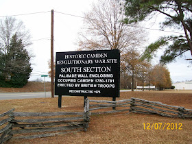
 As we drove into town from I-20 we saw this sign.  I always find the National Park service sites to be extremely well done and informative.  This place was no different.
 Through out the area you could also see signs like this that were also very informative to read.  I did appreciate the way the city had so many signs to read. 


The McCaa was used as a physician office.
The McCaa House, Camden SC
And here's what it looks like inside.  The homes hear are still being renovated.   This house was not typical architecture for this area.
I thought it ironic to have the stockades so close by.


Craven House.
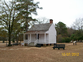
Craven House, Camden SC
I've enlarged the sign in front so you can may see what it says.


Typical one room


The backside of the Craven house.  After seeing this house it makes me appreciate the home that I have.
The Craven House, Camden SC

Drakeford house

Drakeford House, Camden SC


Inside the Drakeford house there were some exhibits about life during the British occupation. 

This was the typical British solider uniform.  I had forgotten they wore red to hid the blood so it wouldn't be so obvious if they were bleeding. 


It was nice to see them including the women's role during the revolution, so often its forgotten.
This is how the palisade wall probably looked. 
In the distance you could see this house- The Kershaw-Cornwallis House. 
Kershaw-Cornwallis House, Camden SC
It look like it would be an easy walk but then you notice this ditch that ran through the field.  It was just steep and deep enough for keeping people away from the place. You could only get there by following the road. 
I did go over to this area and saw the redoubt.

Here's how it looked like if you were looking out of it.
I decided to go ahead and walk up to the Kershaw-Cornwallis house.   This is not the original building but a replica.
And from the other side.  There is a restaurant in it now but you have to have reservations to get into it.

Add caption
One of the things that they consider their mascot in Camden is this weather vain on top of the City Hall.  It is of King Haiglar.  King Haiglar was a Catawba Indian who helped the settlers when they first came to the area and has been considered its patron saint.   The weather vain was created in 1825 by J.B. Mathieu, with the original now in the Camden Archives Museum, and a replica is now on top of the city hall.
King Haiglar weather vain, Camden SC

The area still has a lot of horses.
This is a grave of a famous horse that won a lot of races in its day.
The steeplechase racetrack that is there.


After my spouse was done with the class we had the afternoon off before we had to head home.  I was able to take him to some of the sights I had already checked out and thought would be of interest to him.   He liked the place as much as I did and I could see us coming to visit this area again. Like I said before for a small place it sure did have a lot to see and do there. 

Here's some links to Camden and its history:
http://www.cityofcamden.org/

http://en.wikipedia.org/wiki/Camden,_South_Carolina

http://kershawcountychamber.org/

http://www.historic-camden.net/

http://en.wikipedia.org/wiki/South_Carolina_in_the_American_Revolution
.....

Monday, December 24, 2012

My new Xmas present

For Xmas  I got a smart phone and I'm trying to figure out what it can do.  fof one thing it changed present into presentation. This thing is too sensigive to work with.  i dont thjnk i will be composing much with it.
it makes too many errors
At least i got what i wanted and i hope santa brings you what you want too. Merry Christmas to one and all.

Sunday, December 16, 2012

Congaree National Park, South Carolina

On of my goals in life is to see as many of the United States National Parks as possible.  I've seen quite a few of them already and have always enjoyed visiting them.  I find that usually there is something special geologically about the place and that is why people want to preserve it.  Each park has unique characteristics that make it different from all of the others.   So whenever I travel and I have a little bit of free time the one thing I do is check out if there is a National Park in the area so I can go visit it.
    My spouse had a class to take and I went with him to South Carolina.  I got out my maps and realized that Congaree National Park was in the area.  While he was in class I went and checked it out. 
(I must admit I was given a guide but  with the hectic  holidays I lost it. - Most of the time when I take pictures I'm trying to get the image the guide is trying to explain.  I got the pictures but not a whole lot to write about since I'm not positive about a lot of this stuff.) 
   I do feel confident in saying that Congaree was made into a national park because it was a swamp and has original hardwood forests.

The entrance to the park
 Harry Hampton Visitor center.
 I was there in the winter time.  Most of the fall foliage had fallen and it made it easier to see things.  Because I was there during the time of year that i was - it was a very pleasant excursion. I did not have to deal a lot with the bugs which I'm sure can be overwhelming at times.  Also temperature wise you couldn't ask for a nice temperature while I'm sure in the summertime it can be unbearable with the heat and humidity.
    The path was easy to follow since much of it was a boardwalk.
The boardwalk in Congaree National Park.
 I looked back and got this photo of the visitor center because I thought it loos so pretty.
Harry Hampton Visitor Center @ Congaree National Park
 The day I was there was beautiful.  The skies were so blue and the temperature was perfect for walking.  When I first started out there was a chill in the air but as I walked it quickly became very comfortable.
 Seeing all the water on the ground I could understand why they built the boardwalk.  It sure did making walking in the area easy.
 Living in Louisiana I've seen some swamp in my day and this is very typical of what they look like.  
 I just though this was a pretty picture.

Congaree National Park

 Bald Cypress and their knees are very typical in a swamp. 

 This is the low boardwalk area
 After awhile the boardwalk gave out but there was a well blazed trail for which you could follow.  I choose to follow the Blue - Bluff trail that was 1.7 miles long and went along Cedar Creek.
Cedar Creek, Congaree national park.


Cedar Creek, Congaree National Park

 I was surprised to see this solar panel out in the middle of nowhere but was impressed they were using it. From what I could gather it look like it was helping with instruments to monitor the creek levels.
 There were some planes flying overhead that you could hear occasionally but other than that you really felt like you were in the wilderness and could really enjoy mother nature.
 It was nice to see that the Boys Scouts had helped so much with this park.  The boardwalks really did make a big difference in being able to hike its trails.
 Most of the next shots are just pictures I took because the area was so pretty and peaceful.


 same tree just a different angle. 

 I did like the way the trails were so well marked and you had no trouble following them.


 I was surprised to see this riverbed dried up I expected there to be some water in it even if it was just a trickle.  I guess that is why creeks are called creeks because sometimes they do go dry.

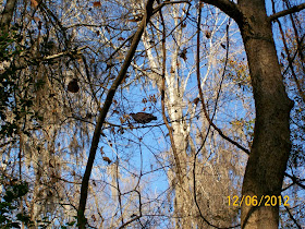
 All of a sudden this huge bird flew into the area.  If I hadn't seen it fly in I doubt if I would have notice it.  It seemed to follow me for awhile and when it decided I was harmless it flew off.
 Here it is flying off - Its near the tree on the left, in the center of the picture.
I saw this whole and could tell something has lived here.  I wonder what animal it was.
I came to Weston Lake and was glad it was labeled as such because it didn't look like it was much of a lake to me ---more like a pond.

Weston Lake, Congaree National Park.
I saw these Dwarf Palmetto's and though they were pretty.
I didn't know what they were but the guide did help in identifying them.
Dwarf Palmetto's - Congaree national park
 I completed the trails and got back onto the boardwalk to get back to the visitor center.

Heading back I kept on noticing my shadow.  I decided to get my picture this way since I was out here all by myself and there was no one else to take it.  That was the one thing that surprised me while I was there - outside of the park rangers I only saw one other hiker and a family that was camping out in the campground.  I'm not used to national parks being this deserted - usually there are a lot more people than that.
The boardwalk - Congareee National Park, SC
  
If you want a secluded national park to visit - this is the one to go to.   I did enjoy seeing its swamps and am glad they made it into a national park.


 Here's its official website.- and it does have the trail guide under maps and brochures.
http://www.nps.gov/cong/index.htmHere's what Wikipedia has to say about it.
http://en.wikipedia.org/wiki/Congaree_National_Park

I'll still be looking for the guide (since I know it was different from the downloads) and other information if I do find it I will be updating this post accordingly.